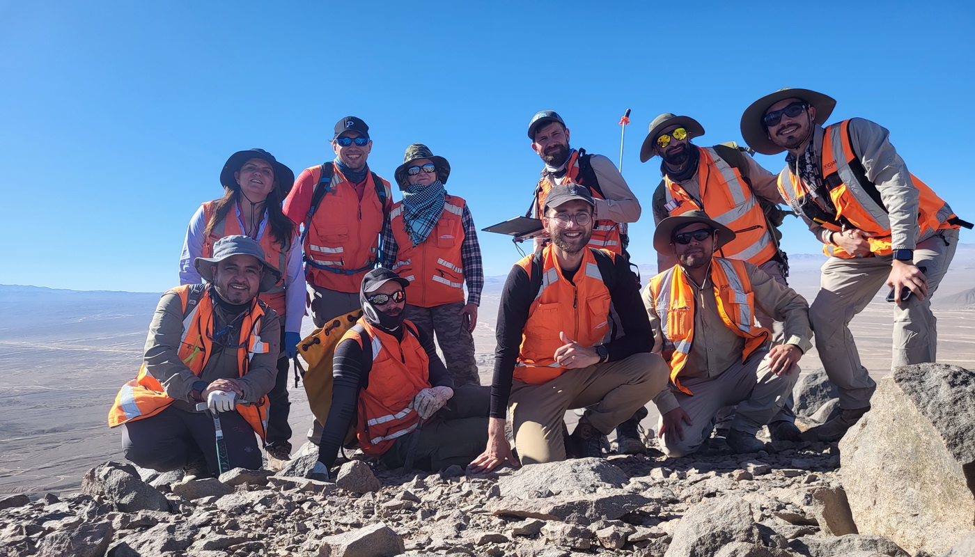
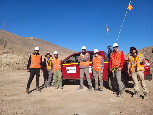
Researchers from the Łukasiewicz Institute of Aviation, in cooperation with Remote Sensing Business Solutions (RSBS), conducted spectral studies in the Atacama Desert in Chile. The trip took place as part of the Hype4Explor project, which supports solutions for the mining industry.
The Hype4Explor project focuses on one, albeit very common, type of deposit, i.e. Porphyry Copper Deposits (PCDs), which are usually polymetallic deposits and are the main source of copper in the world.
One of the tasks in the project involved the validation of mineralization maps created on the basis of satellite images. Test sites located in Chile were selected as the areas for the implementation of the task, because it is a country with a large amount of PCD deposits and at the same time with a minimum amount of vegetation cover, as well as weather conditions for the acquisition of satellite imagery are favorable throughout the year.
Test sites located in the mining area of the Sierra Gorda mine were chosen because RSBS managed to establish a relationship with Sierra Gorda SCM, which enabled legal research work and logistical support in the field. The Sierra Gorda mine exploits the Porphyry Copper Deposit, and pre-project studies and consultations with geologists from the University of Warsaw and Sierra Gorda SCM indicated the presence of surface mineralization zones characteristic of this type of deposit.
The project was also supported by scientists from the Łukasiewicz – Institute of Aviation, whose task was to obtain spectral data. They will be the reference material for the creation of a database of spectral signatures compared with the sampling sites of geological material (designated by scientists from the Faculty of Geology of the University of Warsaw). These data will also be used to create mineralization maps based on hyperspectral satellite data for the three research areas. The areas are located in the Antofagasta region and include the Sierra Gorda mining area, the Sierra Gorda SCM mine and Sierra Limon Verde near the city of Calama.
– Our experience gained in previous R&D projects using spectrometry could be used for the first time in such difficult terrain and climatic conditions. As part of the project, we made about a thousand spectral measurements that will be implemented in the works of RSBS. This process was very demanding from the physical and organizational side, but we showed our ability to carry out this type of work anywhere in the world – says Marcin Spiralski from the Łukasiewicz – Institute of Aviation.
Modern instrument for spectral research
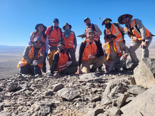
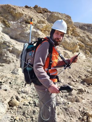
The work carried out by scientists from the Łukasiewicz – Institute of Aviation took place in the mountainous area of the Atacama Desert at an altitude of 1600 to 2500 m above sea level. A portable hyperspectral spectroradiometer with a portable GNSS receiver was used for the study.
As Marcin Maksymowicz, Lead R&D Engineer in the Hype4Explor project, says:
– RSBS decided to cooperate with the Institute, because it is one of the few units in the country that has an ASD FieldSpec Hi-Res field spectroradiometer, which enables the registration of spectra in a very wide spectral range (350-2500 nm). SWIR bands are particularly important for us in mapping specific minerals, hence the use of this instrument was necessary to record the spectral characteristics of rock centers during field work. The Institute has a qualified team of specialists and extensive experience in field research around the world, which makes us open to further research cooperation.
Artificial intelligence will help discover new deposits
The generated surface mineralization maps can be used as low-cost data for interpretation when narrowing the areas of exploration in greenfield areas, and increasing the precision in locating exploratory boreholes, which will translate into reducing the costs of exploration and minimizing the risk associated with negative wells.
In project, however, RSBS goes a step further than just mapping. Based on hundreds of known PCD deposits in the world, RSBS will create artificial intelligence models that by linking surface mineralization with the parameters of already explored deposits (copper content, total tonnage) will indicate the deposit potential of greenfield areas, in order to support optimal decisions at an early stage of exploration work.
Improvement of mineral exploration methods
An additional research goal of the Chilean fieldwork was to create a site-specific library of spectral characteristics of rock media containing specific minerals. This will be used to test the hypothesis regarding the validity of integrating in-situ measurements in the process of creating surface mineralization maps from satellite data. Maps created on the basis of characteristics from publicly available spectral libraries will be compared with maps created using spectral characteristics obtained in the field. In addition, the spectral characteristics of rock centers in conjunction with laboratory tests of the mineralogical composition of the samples will be used to study the detection thresholds of specific minerals.
Further plans and participants of the expedition
During the current scientific expedition, in addition to field research, a number of meetings with the geological staff of the Sierra Gorda SCM mine and KGHM Chile were held, as well as a local inspection of the area for future project’s work took place.
The expedition was attended by scientists from the Remote Sensing Department in Łukasiewicz – Institute of Aviation: Mariusz Kacprzak and Marcin Spiralski and scientists from the Faculty of Geology of the University of Warsaw: Professor Ewa Falkowska and Dr. Rafał Siuda. The RSBS company acted as the leader of the project, whose representative during the expedition was Marcin Maksymowicz.
Hype4Explor project
Hype4Explor is an R&D project implemented by RSBS, which received co-financing from the National Center for Research and Development in the Fast Track – Digital Innovation competition.
The aim of the project is to add a new module to the TerraEye application for mining and the field of exploration and appraisal of deposits. The project will create a decision support system. The creation of the system will include ML and AI algorithms, as well as a lot of geological data to support deposit benchmarking based on satellite data.
The aim of the project is for the new TerraEye application module to enable:
- automatic acquisition and processing of multispectral and hyperspectral images,
- automatic generation of maps of geological indicators, hydrothermal transition zones and surface mineralization maps,
- classification and benchmarking of potential deposit parameters based on artificial intelligence models.
____
The Łukasiewicz Research Network – Institute of Aviation is one of the most modern research facilities in Europe, with traditions dating back to 1926. The Institute closely cooperates with global tycoons of the aviation industry, such as: Boeing, GE, Airbus, Pratt & Whitney, and institutions from the space industry, including the European Space Agency. Strategic research areas of the Institute are aviation, space and unmanned technologies. It also provides research and services for domestic and foreign industries in the field of materials, composite, additive, remote sensing, energy and oil&gas technologies. More: ilot.lukasiewicz.gov.pl/en/
Remote Sensing Business Solutions P.S.A., (RSBS) is a company that processes satellite and aerial data in order to extract business value from them. https://www.linkedin.com/company/rsbs-space/. RSBS provides its customers with sets of digital tools via web applications, including the TerraEye application: https://terraeye.co/